'%20xmlns:inkscape='http://www.inkscape.org/namespaces/inkscape'%20xmlns:sodipodi='http://sodipodi.sourceforge.net/DTD/sodipodi-0.dtd'%20xmlns='http://www.w3.org/2000/svg'%20xmlns:svg='http://www.w3.org/2000/svg'%3e%3cdefs%20id='defs4805'%20/%3e%3csodipodi:namedview%20id='namedview4803'%20pagecolor='%23ffffff'%20bordercolor='%23000000'%20borderopacity='0.25'%20inkscape:showpageshadow='2'%20inkscape:pageopacity='0.0'%20inkscape:pagecheckerboard='0'%20inkscape:deskcolor='%23d1d1d1'%20showgrid='false'%20inkscape:zoom='3.6875'%20inkscape:cx='46.915254'%20inkscape:cy='33.084746'%20inkscape:window-width='1710'%20inkscape:window-height='970'%20inkscape:window-x='0'%20inkscape:window-y='39'%20inkscape:window-maximized='0'%20inkscape:current-layer='svg4801'%20/%3e%3cpath%20id='path4926'%20style='fill:%23000000;stroke-width:0;stroke-linecap:round;stroke-linejoin:round;paint-order:stroke%20markers%20fill;stop-color:%23000000'%20d='M%2030,7.5%20A%2022.5,22.5%200%200%200%207.5,30%2022.5,22.5%200%200%200%2030,52.5%2022.5,22.5%200%200%200%2052.5,30%2022.5,22.5%200%200%200%2030,7.5%20Z%20m%20-10.683106,6.96167%20c%201.862232,0%203.375733,1.513443%203.375733,3.375732%200,1.86229%20-1.513264,3.380127%20-3.374268,3.380127%20A%203.3881105,3.3882163%200%200%201%2015.9375,17.837402%203.3758348,3.3759402%200%200%201%2019.316894,14.46167%20Z%20m%2017.756837,8.864502%20c%205.899725,0%206.988769,3.882968%206.988769,8.929687%20V%2042.53833%20h%20-5.822754%20v%20-9.118653%20c%200,-2.172876%20-0.03918,-4.971679%20-3.0271,-4.971679%20-3.03211,0%20-3.498046,2.369062%20-3.498046,4.812012%20v%209.273193%20H%2025.89331%20V%2023.79126%20h%20-0.0088%20l%200.0088,-0.0037%20v%200.0037%20h%205.578858%20v%202.562011%20h%200.07764%20c%200.778283,-1.473136%202.678406,-3.027099%205.523927,-3.027099%20z%20M%2016.402588,23.79126%20h%205.837402%20v%2018.745605%20h%20-5.837402%20z'%20/%3e%3c/svg%3e)
'%20xmlns:inkscape='http://www.inkscape.org/namespaces/inkscape'%20xmlns:sodipodi='http://sodipodi.sourceforge.net/DTD/sodipodi-0.dtd'%20xmlns='http://www.w3.org/2000/svg'%20xmlns:svg='http://www.w3.org/2000/svg'%3e%3cdefs%20id='defs5445'%20/%3e%3csodipodi:namedview%20id='namedview5443'%20pagecolor='%23ffffff'%20bordercolor='%23000000'%20borderopacity='0.25'%20inkscape:showpageshadow='2'%20inkscape:pageopacity='0.0'%20inkscape:pagecheckerboard='0'%20inkscape:deskcolor='%23d1d1d1'%20showgrid='false'%20inkscape:zoom='1.3350176'%20inkscape:cx='-101.12226'%20inkscape:cy='117.60145'%20inkscape:window-width='1710'%20inkscape:window-height='970'%20inkscape:window-x='0'%20inkscape:window-y='39'%20inkscape:window-maximized='0'%20inkscape:current-layer='svg5441'%20/%3e%3cpath%20d='m%20105,60.1647%20c%200,-24.8526%20-20.1474,-45%20-45,-45%20-24.8526,0%20-45,20.1474%20-45,45%200,21.1032%2014.5296,38.8116%2034.1298,43.6752%20V%2073.9167%20h%20-9.279%20v%20-13.752%20h%209.279%20v%20-5.9256%20c%200,-15.3162%206.9318,-22.4154%2021.969,-22.4154%202.8512,0%207.7706,0.5598%209.783,1.1178%20v%2012.465%20c%20-1.062,-0.1116%20-2.907,-0.1674%20-5.1984,-0.1674%20-7.3782,0%20-10.2294,2.7954%20-10.2294,10.062%20v%204.8636%20h%2014.6988%20l%20-2.5254,13.752%20H%2065.454%20v%2030.9186%20C%2087.7326,102.1443%20105,83.1723%20105,60.1647%20Z'%20fill='%230866ff'%20id='path5439'%20style='fill:%23000000;fill-opacity:1;stroke-width:0.18'%20/%3e%3c/svg%3e)
%20--%3e%3csvg%20version='1.1'%20id='svg5'%20x='0px'%20y='0px'%20viewBox='0%200%20120%20120.00001'%20xml:space='preserve'%20sodipodi:docname='x-logo.svg'%20width='120'%20height='120'%20inkscape:version='1.2.1%20(9c6d41e4,%202022-07-14)'%20xmlns:inkscape='http://www.inkscape.org/namespaces/inkscape'%20xmlns:sodipodi='http://sodipodi.sourceforge.net/DTD/sodipodi-0.dtd'%20xmlns='http://www.w3.org/2000/svg'%20xmlns:svg='http://www.w3.org/2000/svg'%3e%3cdefs%20id='defs4189'%20/%3e%3csodipodi:namedview%20id='namedview4187'%20pagecolor='%23ffffff'%20bordercolor='%23000000'%20borderopacity='0.25'%20inkscape:showpageshadow='2'%20inkscape:pageopacity='0.0'%20inkscape:pagecheckerboard='0'%20inkscape:deskcolor='%23d1d1d1'%20showgrid='false'%20inkscape:zoom='3.0920661'%20inkscape:cx='-24.417331'%20inkscape:cy='55.302828'%20inkscape:window-width='1710'%20inkscape:window-height='970'%20inkscape:window-x='0'%20inkscape:window-y='39'%20inkscape:window-maximized='0'%20inkscape:current-layer='layer1'%20/%3e%3cstyle%20type='text/css'%20id='style4180'%3e%20.st0{stroke:%23FFFFFF;stroke-miterlimit:10;}%20.st1{fill:%23FFFFFF;}%20%3c/style%3e%3cg%20id='layer1'%20transform='matrix(0.14002497,0,0,0.14002333,-50.273153,-31.521857)'%3e%3cpath%20id='path4416'%20style='fill:%23000000;stroke-width:0;stroke-linecap:round;stroke-linejoin:round;paint-order:stroke%20markers%20fill;stop-color:%23000000'%20inkscape:label='path4416'%20d='M%20787.52493,332.24361%20A%20321.37125,321.37504%200%200%200%20466.15367,653.61865%20321.37125,321.37504%200%200%200%20787.52493,974.99364%20321.37125,321.37504%200%200%200%201108.8962,653.61865%20321.37125,321.37504%200%200%200%20787.52493,332.24361%20Z%20M%20565.14899,444.46333%20H%20698.14355%20L%20811.26163,595.71464%20951.26526,444.46333%20h%2039.08343%20L%20828.72154,619.07502%201010.9888,862.77396%20H%20878.00475%20L%20755.17858,698.54001%20603.14445,862.77396%20H%20564.06101%20L%20737.7082,675.19011%20Z%20m%2057.4744,28.80031%20269.79703,360.72047%20h%2061.09402%20L%20683.71741,473.26364%20Z'%20/%3e%3c/g%3e%3c/svg%3e)
Why Maps Get Poland's High-Speed Roads Wrong
Is Poland really a country of just three motorways? Now and then, I come across maps of Europe's major roads that show only three lonely lines in Poland — one running south to north and two stretching from west to east. But seriously? That's not how things look on the ground. So, here's my attempt to map out the “motorway-like” roads across Europe and see where Poland truly stands.
Published November 2024
By Anton Dzeviatau
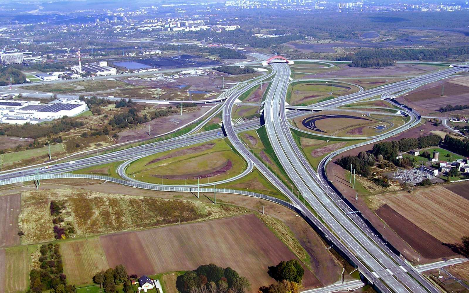
When I moved to Poland 2.5 years ago, one of the first things I noticed after crossing the border was how much the roads had improved since my last trip by car more than a decade ago. I distinctly remember how slow travel was back then. There were endless detours through villages, with heavy trucks ahead, and little chance to overtake them safely. And even if you did, you’d soon find yourself stuck behind another pair of trucks. Construction sites and poorly maintained sections of road also accompanied much of the journey at that time. Now, however, much of these seems to be completed.
Well, to be honest, as I’ve lived here and traveled around, I’ve learned that there’s still room for improvement in some places. But, overall, I’m used to being able to reach any major city from Warsaw via a motorway. By “motorways,” I mean high-speed roads with at least two lanes in each direction, road dividers, multi-level interchanges, and no traffic lights. I mention this because, as you’ll see later, not all roads meeting these criteria are officially classified as motorways.
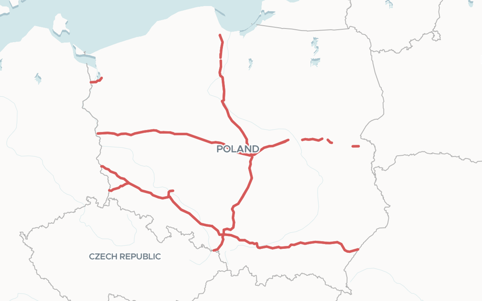
So, why do these maps often show so few roads in Poland? The main reason lies in how roads are classified. In Poland (as in many other European countries), there are two types of high-speed roads: Autostrada (Motorway) and Droga Ekspresowa (Expressway). The catch is that there is almost no difference from the driver’s perspective. While expressways have slightly lower technical specifications and speed limits, these differences are barely noticeable during driving. Additionally, all new high-speed roads constructed here are classified as expressways. The three lonely lines depicted on the maps were built quite some time ago, and their network has not expanded significantly since.
It’s worth noting that these differences aren’t so small in every country. But in some places, the situation is similar to Poland’s. Take Czechia, for example. Before 2016, they had a separate network of expressways alongside motorways. Then one day, they changed the classification, and most of the expressways were reclassified as motorways. With just one regulatory act, the length of their motorways significantly expanded. Voila!
The process
The idea was to extract not only motorways but also roads of the next level of importance from OpenStreetMap (OSM) across all European countries and map them. In OSM, the highway key is used to classify all roads, with the two most important categories being highway=motorway and highway=trunk. However, after examining the results, I realized that trunk roads are not always multi-lane; they are often single-lane roads in each direction without barriers. To filter these out, I added the key oneway=yes, leaving only motorway-like trunk roads and true motorways.
Road classification isn't uniform across countries, and the technical specifications for what qualifies as a trunk road vary widely. For example, the image below shows a trunk road in the suburbs of Madrid, complete with a roundabout and urban bus stops.

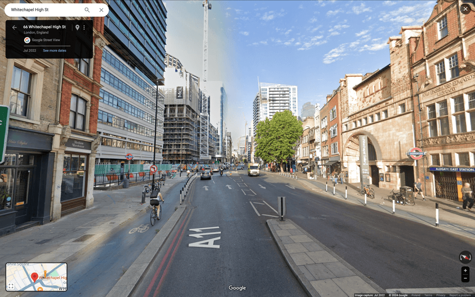
Sometimes, these roads can appear even more unusual due to historical factors. The next image shows a road near the City of London, which was once part of the London to Norwich route. Over the years, this road has been segmented, with one section now enclosed within the city and disconnected from the rest. Yet, it is still classified as a trunk road, including some one-way sections.
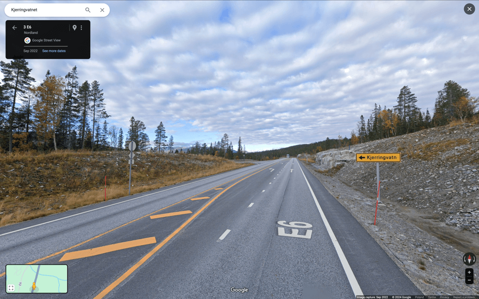
Another issue I encountered was the presence of short multi-lane sections on otherwise single-lane trunk roads in the query results. These sections, which typically appear near junctions where the road widens to form left-turn lanes, sometimes create a “dashed line” effect on the map due to their frequency. To resolve this, I applied a length filter to remove the shortest segments, resulting in a much cleaner final map. Below is an example of such an area, located somewhere in Norway, where this issue was clearly noticeable.
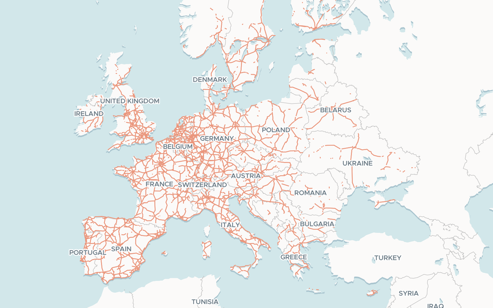
Despite the issues described above, the final result provides a fairly accurate representation of Europe’s motorway-like roads. Most of the problematic sections appear within cities or suburban areas. After manually checking various random points, it seems the final result offers a good approximation for intercity roads. While there are certainly over-represented parts and sections that aren’t shown — despite meeting the criteria — overall, the map answers the core question: “Where in Europe can you drive on motorways or motorway-like roads?”
And what’s on the map?
I didn’t create this map to defend Poland’s road network, but because I simply love making and exploring different maps. Once the map was ready, I spent quite a bit of time digging into it, and here are some of the interesting things I discovered:
It's quite obvious, but yes, the density of roads correlates well with population density and wealth. The grid is much denser in the area of the so-called “blue banana” — the most populated and developed part of Europe.
Outside this area, the road network isn't so different from Poland's. Once all the planned high-speed roads here are completed (and there's no doubt they will be — many are under construction and progressing well), Poland's network will resemble those in Spain, France, or Eastern Germany.
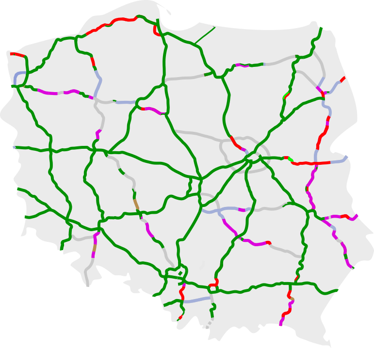
Until recently, the A2 West–East motorway in Poland ended near the town of Mińsk Mazowiecki on its eastern side. However, there is now intense construction underway to extend this road almost to the Poland–Belarus border. This gives some optimism for the future, as it's now nearly a motorway leading toward the “new iron curtain.”
I was surprised to find that there's no high-speed connection between the Baltic states and the rest of the EU, which I thought would be vital for them. In fact, there are not many motorways in those countries, especially in Latvia and Estonia.
Before Bulgaria and Romania joined the EU, Greece was separated from the rest of the Union by non-member states. I was curious if it's now possible to reach Greece via motorway-like roads without leaving the EU. The answer is “not yet,” as there's still no seamless high-speed route through Bulgaria and Romania.
Neighboring Moldova appears to have the fewest motorways in Europe, with only a few relatively short sections near the capital, Chișinău, meeting the requirements.
It’s true that my approach involves some interpretation, so it may not be entirely accurate. But I’m pleased with the result because, from a real-world perspective, it provides a more realistic picture of what can be considered “motorway-like” roads than simply mapping roads labeled as such. There are plenty of interesting spots to explore, and you can check out the map.